


Antique Glens shops Falls, New York 1956 US Geological Survey Topographic Map – Saratoga Springs, Corinth, Warrensburg, Ticonderoga Lake George NY
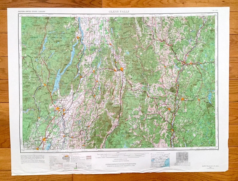
Beautiful, antique map of Glens Falls, New York and surrounding Vermont and New Hampshire areas. This is an authentic 1956 edition, 1967 print from the U.S. Geological Survey and NOT a computer reproduction.
See what New York, Vermont and New Hampshire looked like over 60 years ago. Lots of intricate details and geological contours. Map is incredibly large and in the grand 1:250,000 scale. The USGS cartographers were very thorough back then!
Perfect for the historian, map-lover, the curious or just as a conversation starter. Wonderful and rare. Vintage maps such as these make great gifts.
Edition of 1956, printed 1967
Dimensions: 32" width x 22 1/2" height
----
Features
Cities & Towns: NEW YORK - Glens Falls, South Glens Falls, Hudson Falls, Ballston Spa, Fort Edward, Victory Mills, North Creek, Lynnwood, Whitehall, Greenwich, Palmer, Greenfield, Saratoga Springs, Corinth, Warrensburg, Ticonderoga, Lake George.
VERMONT - Fair Haven, Poultney, Granville, Salem, Cambridge, Brandon, Rutland, West Rutland, Protor, Wallingford, Springfield, Windsor, Woodstock, Bellows Falls.
NEW HAMPSHIRE - Claremont, Newport, Enfield, Lebanon, West Lebanon, North Walpole, Hanover.
Points of Interest: NEW YORK - Hudson River, Lake George, Lake Champlain, Schroon Lake, Adirondack Mountains, Fivemile Mountain, Luzerne Mountains, Huckleberry Mountain, Adirondack State Park, Kayaderosseras Range, Island shops Pond, Berrymill Pond and lots more hills, mountains, rivers, lakes, creeks, roads, highways and railroads.
VERMONT - Lake Champlain, Lake Bomoseen, Green Mountains, Green Mountain National Forest, Braintree Mountain, Killington Peak, Connecticut River, Somerset Reservoir and lots more hills, mountains, rivers, lakes, creeks, roads, highways and railroads.
NEW HAMPSHIRE - Connecticut River, Cottonstone Mountain, Moose Mountain, Croydon Mountain, Lempster Mountain, Sunapee Lake and lots more hills, mountains, rivers, lakes, creeks, roads, highways and railroads.
Condition: Very Good Vintage condition, commensurate with age. This map is in gerat shape for being over 50 years old. Has light edge-wear and tears, all of which will read as vintage character when framed.
----
We will happily adjust shipping price for multiple purchases. Maps are rolled up and shipped in sturdy mailing tubes, never folded.